A surveyor as well as the results of a survey are only as good as the equipment they use. In order to get prime results, one has to rely not only on their skills but mostly on their tech, meaning that carrying or having the right surveying equipment with you is an essential part of the entire survey.
As there is a lot that can be covered in terms of the equipment and surveyor would need in the field, we want to emphasize only the best surveying equipment needed for any kind of job, making this a selection that would satisfy almost any type of surveyor.
Total Station - Leica TS60
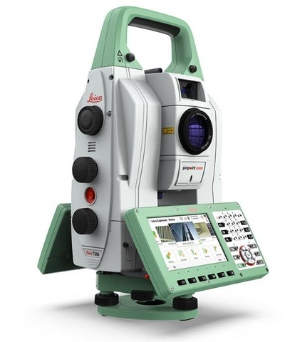
Caption: "Leica TS60 Surveying Total Station"
The Leica Nova TS60 is celebrated as the world's most accurate total station. Designed to tackle the most challenging projects, it boasts an unprecedented angular accuracy of 0.5" (sub-second) and distance accuracy of 0.6mm + 1ppm (sub-millimeter). These advanced specifications assure unmatched performance even in the harshest conditions—rain, fog, dust, intense sunlight, heat shimmer, or reflections. If the line of sight is disrupted, the TS60 offers the fastest re-lock in the industry.
The TS60 comes equipped with Leica Captivate, an intuitive onboard software incorporating a suite of easy-to-use apps that address all measurement tasks. This advanced software transforms complex data into realistic, workable 3D models.
To enhance productivity, the TS60 integrates Dynamic Lock functionality, which automatically locks onto moving prisms, thus eliminating manual waiting time. Also, with the revolutionary Auto Height feature, you can set up your instrument quicker with a mere button press, getting you started on your next project more swiftly.
Here are some scenarios where the Leica Nova TS60 becomes indispensable:
- Construction Stakeout Tasks: The TS60's high precision makes it ideal for staking out design data or guiding prefabricated elements to their designated position.
- Reference Network Measurements: For construction and infrastructure projects, defining the reference network frame with precise angle and distance measurements becomes feasible.
- Building and Structure Measurements: It comes handy in bridge condition or clearance analysis, Building Information Modeling (BIM), and as-built measurements.
- Prefabricated Element Checks: The TS60 is perfect for as-built checks and dimension control in shipbuilding and wind turbine construction.
- Monitoring Measurements: It is ideal for either permanent or campaign monitoring of bridges, buildings, and steel structures.
- Slab Track Installation and Railway Clearance Surveys: It ensures accurate control of slab track installation and clearance surveys in railway projects.
In conclusion, the Leica Nova TS60 is an essential tool for any serious surveying engineer who requires the highest degree of accuracy and reliability in their surveying work.
GNSS RTK Rover - Leica GS18 T
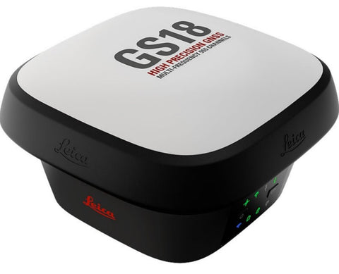
Caption: "GNSS RTK Rover - Leica GS18 T"
With the Leica GS18 T, forget the bubble and focus on your task. This GNSS smart antenna is a genuine tilt-compensating solution immune to magnetic disturbances and free from calibration. The fusion of Global Navigation Satellite System (GNSS) and Inertial Measurement Unit (IMU) makes this breakthrough technology possible. For GS18, T represents tilt.
The GS18 T functions right out of the box and can serve as both a rover and a base, offering instant operation and flexibility. This system partners with the Leica Captivate field software, providing an intuitive platform for managing and visualizing data in 2D and 3D, across diverse applications and industries.
In the realm of tilt compensation, the GS18 T stands unrivalled. It allows measurements with a levelled pole while storing the tilt values, ensuring accuracy and trust in your data. With either an SD card or internal memory, users have the flexibility to log raw data as per convenience.
The GS18 T embodies superior measurement quality by tracking multi-frequency signals, coupled with an excellent GNSS antenna and a 20 Hz position update rate. With Captivate's interference mitigation and multipath reduction features, it promises enhanced GNSS signal tracking quality, even in harsh environments, improving RTK availability and accuracy.
The antenna also incorporates Active Customer Care (ACC), a global network of experienced professionals at your fingertips to navigate through any challenge. This, along with a customizable Customer Care Package (CCP), ensures comprehensive coverage, anytime, anywhere.
The Leica GS18 T isn't merely a GNSS smart antenna—it's a game-changer in geodetic surveying, an indispensable tool that makes complex tasks more efficient and straightforward. Its high accuracy, speed, and portability, even in challenging environments, makes it an essential asset for any geodetic task.
Controller - Leica CS20
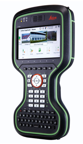
Caption: "Leica CS20 Controller"
Experience the apex of control, convenience, and mobility with the robust, high-performance Leica CS20 controller. The CS20, adorned with Red Dot award-winning product design, allows you to take your entire office on the go, turning complex data processing tasks into enjoyable experiences.
Touch screen technology and a stunning 3D view revolutionize your Leica Viva GNSS and Leica Nova scanning experiences. Moreover, the CS20 incorporates an integrated DISTO™ for accurate electronic distance measuring and features radio and antenna for long-range robotic total station control.
The CS20 comes equipped with the game-changing Leica Captivate field software, enabling the capture and management of complex data with a simple swipe. It transforms intricate data into the most realistic and workable 3D models. With user-friendly apps and familiar touch technology, all types of measured and design data can be viewed in all dimensions, catering to various industries and applications.
Leica CS20 also offers Active Customer Care (ACC), giving you access to a global network of professionals to guide you through any challenge at a click. It provides superior technical service, consultancy support, and online services for data transfer directly from the field, thus eliminating delays and avoiding costly site revisits. A tailored Customer Care Package controls your costs, providing peace of mind that you're covered anytime, anywhere.
The Leica CS20 controller, combined with easy-to-use software and instruments you trust, forms an all-encompassing solution for your most demanding geodetic tasks. This epitomizes the Leica Captivate Experience, delivering not just a product but an intuitive, robust, and reliable solution.
Digital Levels - Leica LS15 and LS10
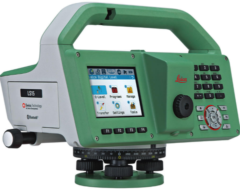
Caption: "Leica LS15 Digital Leveler"
Experience unrivalled efficiency and accuracy in levelling tasks with the Leica LS15 and LS10 digital levels. Offering automated functions and a stellar 0.2mm accuracy, these levels let users display their measuring prowess and effectively execute any project.
These digital levels enhance the entire measurement process through features like autofocus and touchscreen displays with clean layouts. Common levelling concerns, such as misreading the staff or transcription errors, are eliminated. Offering highly reliable results via understandable line flows and color visuals, these levels make daily tasks a more enjoyable experience.
Benefit from Leica Geosystems' experience as the pioneers and industry leaders of digital levels. These instruments have been refined to an art form, delivering faster results with the highest accuracy.
The Leica LS digital levels extend their functionality beyond the field. Once your data is transferred to the office, Leica Infinity processes your results without any hassle. This intuitive software offers easy-to-understand displays of complex levelling data.
Through Active Customer Care (ACC), a global network of professionals is a click away to expertly guide you through any challenge. Enjoy superior technical service, excellent consultancy support, and online services for sending and receiving data directly from the field. Control your costs with a tailored Customer Care Package, assuring peace of mind that you're covered anytime, anywhere. The Leica LS15 and LS10 are not just digital levels; they're comprehensive solutions for all your levelling needs.
Best Surveying Prisms for 4 Different Surveying Scenarios
In the complex and detail-oriented world of surveying, selecting the right prism can significantly affect the accuracy and efficiency of your work. Depending on the specific surveying scenario, different prisms excel in certain areas, offering distinct advantages. Here, we explore the best surveying prisms suitable for four different surveying scenarios, offering you insights into their unique features, and guiding you towards making an informed decision for your specific needs.
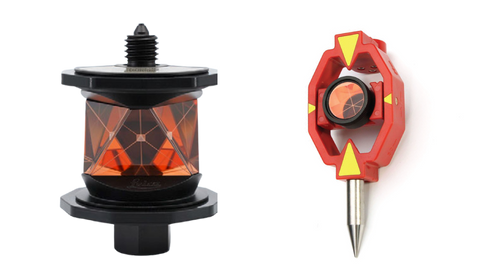
Topographic Surveying
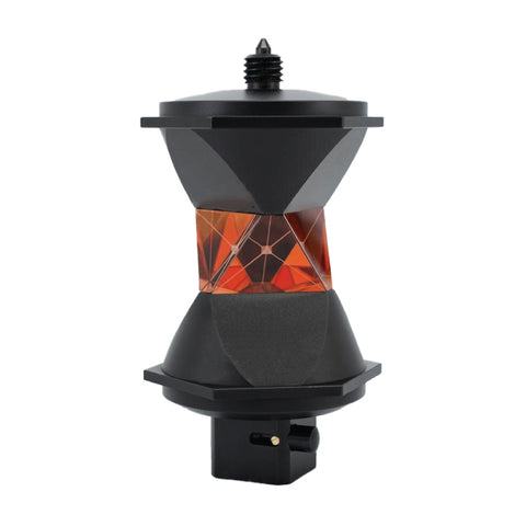
Caption: "Leica GRZ122 - 360 Degree Prism"
The Leica GRZ122 360-Degree Prism sets a new standard in topographical surveying. Specifically designed for Leica Total Stations, this prism brings unprecedented levels of accuracy, range, and flexibility to your surveying toolkit.
The GRZ122 boasts a unique Height Offset of 86.0mm and a Prism Constant of +28.1mm, ensuring precision in each measurement taken. Furthermore, the Beam Deviation of just 3 arcsec guarantees exactness even in challenging surveying conditions.
With its impressive Working Range of 2,000 ft. (600m), the GRZ122 can cover substantial surveying areas without losing precision or efficiency. Whether dealing with large scale or intricate topographical surveys, this prism has got you covered.
The GRZ122's 5/4" Thread Mount allows for easy installation and secure positioning, while its high-quality Copper Coating enhances durability and longevity in all weather conditions. Its sturdy build and coating allow the GRZ122 to maintain optimal performance even in harsh environments.
Furthermore, the GRZ122 comes with a Carrying Bag. Not only does this enhance the prism's portability, but it also provides an additional layer of protection, prolonging the life of the prism.
In conclusion, the Leica GRZ122 360-Degree Prism offers an unbeatable combination of precision, durability, and versatility. Whether you're surveying wide expanses or targeting specific points, this prism ensures you're equipped with the best tool for the job. The GRZ122 isn't just a prism - it's a game-changer in topographical surveying.
Construction Surveying
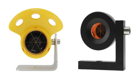
Caption: "Leica GMP104 and GPR112 - Monitoring Prisms" In the demanding environments of tunnel, highway, and bridge construction, specific tasks require highly accurate and reliable tools. This is where monitoring prisms and mini prisms, such as Caption: "Leica GPR121 attached on Leica Carrier and Tribrach"Recommended products
2 optionsMonitoring Surveying - Tunnel, Highway, and Bridge Measurements
Recommended products
2 optionsSurveying Network Measurements with High-Quality Equipment